Records for over 20,000 properties now available to view online.
Pittsburgh, PA – Today, the Pittsburgh Water and Sewer Authority (PWSA) released an initial batch of water service line information for over 20,000 properties. Customers can view this information by neighborhood or property address using a searchable web map. The data released today was compiled by scanning over 120,000 paper records, many over 100 years old. PWSA will post thousands of additional records online in the coming months. Most of the records were created at the time of original construction and do not reflect current conditions, but the newly-available information will help customers make informed decisions about their tap water.
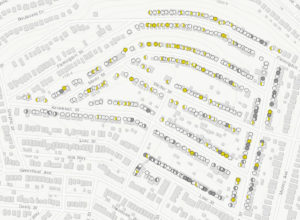
A map of lead service lines is available on our website at www.pgh2o.com/leadmap. It displays available records for the PWSA-owned portion and the portion owned by private property owners. Use the legend to understand the material of the pipe. Click on a circle and a pop-up window will appear with the property’s address and additional information about the service line.
Until recently, information about the type of water service line at each property – typically made of lead, copper, or cast iron – was stored on paper records that were rarely updated. PWSA started reviewing, scanning, and mapping these records in July 2016. The map displays the available records for the PWSA-owned portion (from the water main to the curb) and the privately-owned portion (from the curb into the home) of the water service line. PWSA will complete a water service line material inventory for all homes in its drinking water service area by 2020.
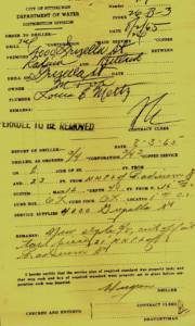
Pictured above is an example of a historical record. These were created at the time of property construction, but many haven’t been updated over time. PWSA is loading information from over 120,000 paper records to the online map on an ongoing basis.
“The safety of our water is our number one priority, and we’re particularly concerned about pregnant women and young children who are most at risk for lead exposure. Our excavations, water line replacements, and curb box inspections show that many of the historical records are no longer accurate because lead lines have been replaced since the old paper records were created. However, we’re committed to transparency and sharing all available data, so customers can make informed decisions,” said PWSA Executive Director Robert A. Weimar.
In addition to reviewing the information included on the map, PWSA encourages residential customers to take advantage of PWSA’s free water lead test kit program. If records indicate a lead line may serve their property, customers should run their taps for a few minutes before using for cooking or drinking. Filters certified to remove lead in water are also available at most hardware and big box stores.
The map also includes results from recent curb box inspections, and the areas identified for upcoming lead service line replacements. Additional data related to PWSA’s multiple lead programs will be posted to the map on an ongoing basis.
PWSA is replacing 2,100 residential lead service lines by the end of 2018. Customers identified for replacement under this program will be contacted by the Authority. Customers who wish to replace a private lead service line at their own expense should contact PWSA and we will replace the public portion at the same time at the Authority’s expense, if it is also made of lead.
Customers who need assistance accessing the records online may contact PWSA’s Lead Help Desk at 412.255.8987.
Resources
Lead line map instructions
Lead line map
Frequently Asked Questions about lead in water
Lead test kit request page
Certified water filter coupons
PWSA Lead Facts webpage